Introduction
For
this paper, I’d like to meld together a variety of sources (see a complete list
at the end) to paint a word picture of how the neighborhood I grew up in was
formed and grew during my early years. I have chosen the beginning date for two
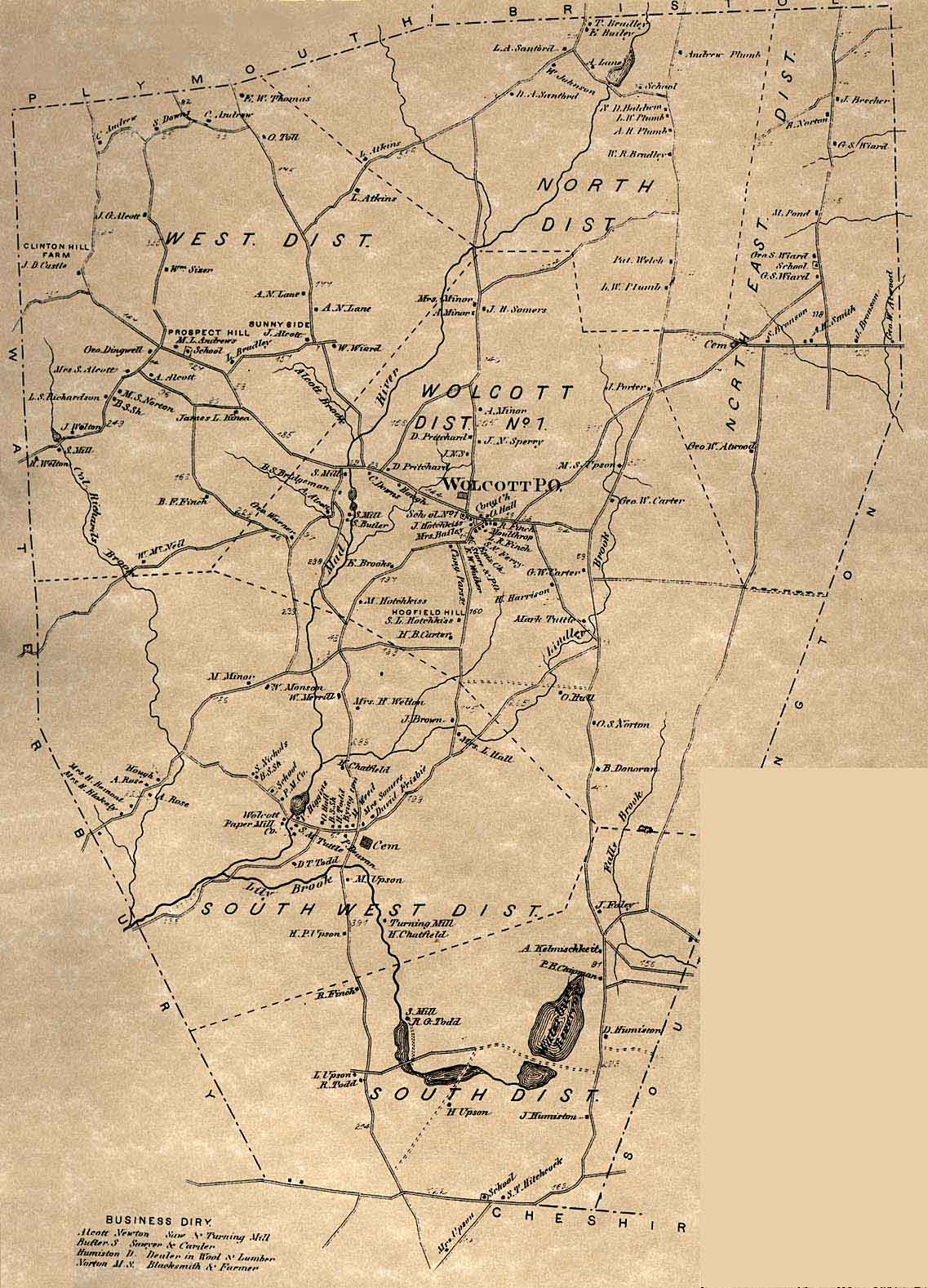
reasons. One is the existence of a 1934 aerial view of Wolcott that shows what
roads and houses existed at the time. The second is that 1935 was the year that
the first paved road in Wolcott was built. Route 69, also known as Wolcott
Road, or at the time the Waterbury-Bristol Road was created, partly by
improving some existing roads, and partly by pushing through undeveloped land.
But this new road opened up the northern reaches of the town (which is where I
grew up) so that people (other than farmers) could have homes there and still
be able to commute to jobs in Waterbury. I chose the ending year, not because
it was a convenient 20 year period from the start, but because further developments
in my neighborhood changed its boundaries (more on that below). This paper also
turned out to be much longer than I envisioned, partly because I discovered
some things that I had never known before that are exciting (at least to me).
Defining my neighborhood
The
period of this paper covers from the year I was born (1948) until completion of
my first grade year at Alcott School. Since I was hardly walking around the
neighborhood on my own much before I was three, and I wasn’t roaming the
streets of Wolcott even at age 7, my neighborhood was fairly limited.
Therefore, I’d like to define my neighborhood as (a) the stretch of Wolcott
Road from the intersection with Long Swamp and Woodtick Roads up through the
intersection with North Street (but only the eastern side of the road), and (b)
the then unpaved roads on the east side of Wolcott Road consisting of Witham
Road, Seery Road (which only existed as a road as far as Barclare Lane, and
Barclare Lane (which only ran back to my Uncle’s house and the Bristol Radio
Shack at the time).
The years until my birth –
1935-1948
As
the 1934 aerial view shows, there were almost no buildings in my neighborhood
at the time. There were a few farm houses on the west side of what was called
(in the 1930 census) “Central Bristol Road”. Homes still existing from before
1935 include the one which is now 1583 Wolcott Road built in 1883, and the
small farm house at 1543 Wolcott Road built in 1880. (Note that I am giving
these homes their current house number, but no such numbering system existed
back then.) According to the 1930 census, there were only a total of 5
dwellings all the way from Long Swamp Road to the Bristol line. But in 1935
that all changed! The construction of the paved “Waterbury-Bristol Road” opened
up the north end of Wolcott to those who had jobs elsewhere as it was now an
easy (and paved) commute. (Note that I’m going to refer to this road as Wolcott
Road in the below to avoid confusion.)
The
first homes constructed were those right on Wolcott Road. Before the end of the
decade, there were about a dozen homes built on the east side of the road. The
earliest was built in 1934 (but after the aerial photographs were taken), and
the newest was built in 1945. I’ll go through these houses one by one in the
next section. I’m also going to ignore all the homes on the west side of
Wolcott Road, partly because these homes did not have any children around my
age and partly because crossing Wolcott Road was not something that my parents
allowed me to do at such a young age. Even walking along the shoulder of the
road was something to be done cautiously. In contrast, all the homes on the
east side of the road could be reached through their backyards from Seery Road.
The
new side road of Witham Road was built to give access to the home of Mr. Witham
and a short section of Seery Road (built to give access to the property
holdings of Tom Seery, who lived at 1584 Wolcott Road, the first house built in
that section of the main road). The following homes were built on these new
unpaved roads: 70 Seery Road (the home of Mr. Witham) (1941), then 58 Seery
Road (1943), followed by 12 Barclare Lane (1947), and 62 Seery Road (1948).
My Early Years and My
Neighbors
The Side Roads
My
parents bought the home of Mr. Witham in 1946. He had built it in 1941 and I’m
not sure why he decided to sell it.
Down
a short right-of-way next to us was a tarpaper covered sawmill owned by “Otto”.
His mill was powered by an old car engine sitting outside the building (to
prevent fires) that ran a pulley system inside for saws, planers, etc. The
sawdust was blown out pipes on the backside that actually piled the woodchips
on the edge of our property. I never knew him by any other name but Otto. In
later years the mill was torn down and the property (which turned the corner
and had frontage on Barclare Lane as well) had a house built on the Barclare
Lane side.
In
1948 the Chartier family built a very small house (only about 600 square feet)
next door to us. They were very reclusive and I can only recall being in their
home one or two times all the years they were there. They had one daughter,
Ruth (called Ruthie), who was four years younger than I, so she being both
younger and female was not part of the group of kids that I ran around with. They also had two older children, Janice (who became a nun), and David, but they were enough older that I had little interaction with them. (In
later years the family finally added on to the house - and more than tripled the square footage of it. Ruth and her husband later purchased the family home and still live there.)
Next
to Chartiers and on the corner of Barclare was a small house which had been
built in 1943. I don’t recall the original owners, but do recall that a family
with the name of Gracie bought it in the mid-1950s. I seem to remember that
they were friends of the Merchants who built a house across the street in 1955.
The Gracies had two boys younger than I and were never part of the group of
kids I played with.
Apparently after Mr Witham sold his house to my parents he bought another piece of property and began building another house in 1947. My
uncle and aunt bought it from Mr Witham in 1948. When they went to the town hall to register the sale they were told that the road needed a name, so they had the opportunity to name the “road”
running back from Seery Road to their house Barclare Lane after themselves (“Bar” for Barbara and “Clare” for Clarence).
The
only other structure on that road was a 12’x12’ tarpaper shack that was used by
the Bristol Radio Club for their shortwave radio setup.
Wolcott Road
I’m
going to go through these homes from north to south. Since I’m trying to
describe things that are now more than 60 years ago when I was seven or
younger, I may have some facts incorrect. I’ve tried to check things out by
referring to the census data of 1940, but trying to correlate the names with
the houses when some of them had not yet been built has been challenging. So
please bear with me and forgive any mistakes you may notice. I’m going to list
these homes by their current house numbers, but as I said before, these numbers
didn’t exist at the time.
1660
(built in 1934) – this is the oldest of the homes, it was apparently built
after the aerial photograph of 1934. The Lewandoski family lived here and they
were the only ones who on the 1940 census when asked where they had lived in
1935 replied “same house”. Their house abutted the far corner of my father’s
property which ran behind all the houses from Witham Road as far as North
Street. They were an older couple who had been born in Poland.
1652
and 1642 – these were a pair of bars, not homes. It always intrigued me that
the only two bars in our entire end of the town were located right next door to
one another.
1624
(built in 1941) – the home of the Pearson family. In the 1940 census this
family was renting the house at 1612, but that appears to have been a temporary
situation until their home was completed. This was a couple with 5 children in
1940, but they had even more children later. One of them, Jimmy, was about my
age. They moved to Wolcott from Waterbury.
1618
(built in 1939) – the home of the Greene family. I seem to recall that the
Greenes and the Pearsons were related. They also had a large family with 6
children in the 1940 census with more later. They also had a son about my age
later. They also moved to Wolcott from Waterbury.
1612
(built in 1939) – was being rented by the Pearsons in 1940, but later was owned
by another family with no children (that I can recall).
1600
(built in 1940) – see section on the Seery Farm below for why this one was not
sold until 1940. My sister remembers the name as something like Bikulcius. They did not have any children.
1596
(built in 1944) – see section on the Seery Farm below for why this one was not
sold until 1944. Was owned by the Levine family. They had identical twin boys, Ronnie
and Richard, who were several years older than I was.
1590
(built in 1938) – Initially owned by Robert Seery, the older brother to Tom
Seery. Robert moved back to Plymouth in 1942 and the house was sold to the
Carnein family who lived there when I was growing up.
1584
(built in 1935) – See section on the Seery Farm below for more information.
This was the home of Tom Seery, his wife and three children. The oldest son,
also named Tom, was 14 years older than I was. Barbara was about six years
older and was often our babysitter. She was friends with my cousin Carolyn as
they were the same age and went to school together. The youngest son, Paul, was
a couple of years older than I was. It was he who taught me how to ride a
bicycle.
1576
(built in 1939) – was owned by the Boynton family from Maine. They did not have
any children my age, so I know little about them.
1570
(built in 1938) – was owned by the Markot family from Bristol. Jackie Markot
was my age and I am still friends with her on Facebook.
1556
(not sure of the original date of construction as the original building is now
torn down) – Martin’s gas station and store. This is where all the neighborhood
kids would go every time they had sufficient spending money and buy candy. A
popular place to be for sure.
Schools and Busing
When
my parents married and moved to Wolcott in 1946 the town was still operating
with a group of mostly one-room schools in individual school districts (see
references for a map from 1868 that shows them all). But the town was beginning
a period of explosive growth and that era was about to end. The residents had
voted the prior year (1945) to authorize the building of a new multi-room
school on Woodtick Road, Alcott School. This was initially a six-room school,
but two more rooms were added a short time later. The school opened in 1947(see
italicized note below) and all the students from the one-room school on North
Street (the North District), as well as the one on Beecher Road (the North East
District) were transferred to this new school.
In
1948 Daniel Goffred and his wife began the Goffred School Bus Company and began
the first school bus services in town. The first three buses were 1948
48-passenger Internationals (that’s 8 rows of seats). They were distinguished
by having different interior paint colors (as I recall they were powder blue,
pink, and light green). Bus 3 was the one used in the northern part of town. Busing
only became necessary because of the change from the walking-only district
schools to regional schools. After Alcott, Frisbie School opened in 1950 but
three buses were still sufficient. Bus 4 was added in 1954 and was a 54
passenger Ford with dark green interior. More buses were added in later years
with the opening of Wolcott High School in 1957, Wakelee School in 1961, and
Tyrrell School in 1964.
(I am unsure of the exact dates here. In the
1946 map of Wolcott it is obvious that Alcott School does not yet exist. And
the Goffred Bus Company was definitely not started until 1948 – as confirmed
both by the buses he used and the date given in his wife’s obituary. So while
the 175th anniversary booklet for Wolcott gives a year of 1947 for
when Alcott opened, I tend to think that the school and the busing both began
in the fall of 1948.)
When
I began school (which started with first grade in those days), I got the bus
out on Route 69 (Wolcott Road) with all the other students who lived on “the
highway”. I was the only school-aged student back in our little collection of
unpaved roads. So I rode the bus with Paul Seery and we waited right alongside
the highway. Route 69 was much less traveled then than it is these days, so it
was perfectly safe, but still having a bus stop (without the crossing arm and
the extended stop sign on the side of the bus as they have these days) on a
main road was less than ideal.
As
a side note – Danny (that’s what he was called) ran the school buses from 1948
until 1988. He never had any problems and the town gladly renewed his contract
every few years. Danny had always been a
political independent, but one year in the late 1960s someone convinced him to register as a
Republican so that he would have a vote in the primary as well as in the
general election. Then, the following year, when the new administration was
elected in town and they were Democrats, they are said to have let someone else
know what Danny had bid for the next contract and then let the other company
just slightly underbid him so they could award the contract to a fellow
Democrat instead of to a Republican. Many people in town were somewhat upset
since Danny had always acted in a non-partisan way and always had the best
interests of the town in mind. Danny kept his buses and was able to regain the contract again a few years later, but the "dirty politics" of the situation forever left a bad taste in my mouth.
A new neighborhood and
the end of this era
Development
of other streets outside of my early neighborhood happened at not quite the
explosive rate that the homes were built on Wolcott Road. Development on Long
Swamp Road lagged the building on Wolcott Road by 5-10 years. There were one or
two homes built in the late 1930s, the lots on the north side of the street
were built on in the early-mid 1940s and those on the other side of the street
during the 1950s. (If you look at the 1946 map of Wolcott on the Wolcott
History website, you can see most of this.) In the late 1940s a dirt road was
pushed through to a single home on Idlewood Road. The rest of the homes on this
road were not built until it was paved in 1953.
But
it was in 1955 that the change that forever changed “my neighborhood” happened.
Tom Seery, who owned much of the land surrounding us, completed the rest of
Seery Road, changing the narrow path that went through the woods and across the
small swampy area into a real road. He also opened up the remainder of Barclare
Lane to its present size and added Catherine Drive as well.
All
of these changes meant that when I started second grade in 1955, there were
several more school-aged children in the neighborhood (my sister, my cousin
Dave, Dave and Bobby Merchant in their new home on the corner of Seery and
Barclare, and others), but my bus stop was now at the corner of Seery and Long
Swamp with other students from the several homes on Long Swamp. And with all
these new friends and me being a year older and allowed to roam farther from
home, the little neighborhood that I had enjoyed was now greatly expanded.
If
you look at the map of Wolcott from 1953/55/56 on the Wolcott History website,
the top section is from 1953. You can see all the homes on Wolcott Road and on
Long Swamp Road. Barclare Lane has not yet been pushed through and Seery Road
is still an unpaved path. Just two years later all the homes on Barclare Lane
and Catherine Drive were being built. The number of homes in “my neighborhood”
grew by a factor of 3-4 in just a few years. But that also increased the number
of friends I had to interact with and my own personal worldview would be
expanded as well.
The Seery Farm
When
I started writing this paper I did not envision this section being part of it,
but there were too many miscellaneous facts that were disconnected at the time
that all came together when I found that the house next to Tom Seery in the 1940
census was being lived in by Robert Seery. In checking to see if they were
brothers, I looked at their entire family and the census records from 1900 to
1940 for each of them. I saw that their father (also named Tom) was a farmer in
Wolcott. In the 1900 and 1910 census he was renting the land, but in 1920 he
owned it. And where was this land? In the left hand side of the page of the
1910 census was written vertically and very faintly, “Plumb Street”. But where
is Plumb Street? Again, the key was that many of the early street names in town
were the names of the original families who lived on them. In the 1868 map of
Wolcott, there are four Plumb families, all of them in the North District and
along what is now the northern end of Woodtick Road and its continuation all
the way to the Bristol line, i.e. the current Wolcott Road. This meant that the
Seery family was living in the area for several decades and farming with their
large family of nine children – it must have been a sizeable farm.
I
am almost certain that the Seery family farmhouse was the house currently at
1583 Wolcott Road – the only one large enough to hold a family of that size –
and coincidentally right across the street from the home that Tom Seery built
for himself at 1584 Wolcott Road in 1935. But in 1922 the older Thomas Seery
passed away and the family gave up farming. In the 1930 census Tom is living in
Bristol with his wife and his mother (who lived until 1950). However, they did
NOT sell the family farm, they only stopped farming. Here is the most probable
order of events.
In
1934, the construction of the Bristol portion of what would become Route 69
began. You can see the new swath of road curving up the hill from Bristol all
the way to the Bristol-Wolcott line. Since this was a paved road, there would
have been a need for sand – and Tom knew where to find it. He began “mining”
the sand next to the home where I would eventually live and having it trucked
to the construction site (for a profit I’m sure). You can also see the active
sand pit on the 1934 aerial photo.
Realizing
the potential that the construction of such a road would bring to Wolcott, Tom,
probably with the consent of his mother, also began subdividing that portion of
the property that abutted the only two existing roads at the time – Plumb Road
aka Center Bristol Road aka Wolcott Road aka Waterbury-Bristol Road aka Route
69, and Long Swamp Road. The Seery property ran all the way along Long Swamp
Road as far as what is now 125 Long Swamp Road. The first house built was in
the very corner of the property and was for the Lewandoski family. But why
them? Because they were actually neighbors of the Seerys in the 1920 census and
had nine children of their own. But because most of their children were grown
and had moved away they were looking to downsize. The second house that Tom
built was his own – right across the street from the original Seery family
homestead. He continued this same practice with all the lots facing Wolcott
Road (which was completed in Wolcott in 1935), as well as with all the lots on
the northern side of Long Swamp Road. He left space for Seery Road – a paper
street that ran behind all the properties on Wolcott Road and for connectors at
each end – one on to Long Swamp Road and one on Wolcott Road. The only
properties he did not develop initially were 1596 and 1600 Wolcott Road as that
is where the access to the properties in the back (both the sand pit and the
saw mill) were located.
In
1940 Tom had his first offer to buy property in the interior of his property –
from a Mr. Witham. Initially it appears that Tom’s plans were for one access
point to Wolcott Road at the proposed northern end of Seery Road where it would
bend and come out between what is now 1624 and 1642 Wolcott Road, i.e. after
the last house and before the two bars, and a secondary access point that would
directly connect with the right-of-way leading back to the sawmill. But Mr.
Witham wanted a connector that would come right to his front door. So the
second access point was moved right next to what is now 1612 Wolcott Road and
was called Witham Road. The two undeveloped lots between 1612 and Tom’s brother’s
house at 1590 were shifted 50’ to the south. The lot at 1600 Wolcott Road was
sold that same year (1940) and the lot at 1596 in 1944. Mr. Witham bought a 23
acre parcel that extended all the way to the northern edge of Tom’s property
and back to where the property began to drop off into the swampy area to the
east of Tom’s property. This still left Tom with sufficient internal property
to complete Seery Road (although the section to the north of Witham Road
remains a paper street even to this day since it was never needed to give
access to any other properties), and to push through Barclare Lane and
Catherine Drive in order to develop all the internal lots.
With
this last piece of the puzzle, a lot of my unanswered questions have a
solution:
·
Who initially built what is now known as
Russell’s Pond? Tom Seery the elder in order to have water supplies for what
stock and/or crops he was growing on his extensive farm.
·
Who operated the sand pit? Tom Seery the
younger in order to sell the sand to the company who was constructing the new
road – both the Bristol portion initially and likely the Wolcott portion as
well.
·
Why is the northern portion of Seery Road
still a paper street? Because once Mr. Witham bought such a large piece of the
Seery Farm it was not needed for access to any other internal lots at that end
of the farm.
·
Who was responsible for all the
subdivision in the area? Tom Seery the younger who sold off a total of 19 lots
along Wolcott Road and an additional 19 lots along the northern side of Long
Swamp Road (in addition to 52 internal pieces of property). Only much later was
the Russell property divided into 11 parcels including the Russell Preserve.
·
Why did Tom Seery choose the particular
piece of property for his own family? Because he could see the farmhouse where
he had been born out his front window and see straight down Barclare Lane to
the end of his property out the back window.
There is probably more to the story of Tom Seery, but the above will suffice for this paper. I still have a few unanswered questions as well such as (1) who was "Otto" who owned the sawmill, and (2) where did Mr. Witham come from and where did he disappear to just a few years later.
There is probably more to the story of Tom Seery, but the above will suffice for this paper. I still have a few unanswered questions as well such as (1) who was "Otto" who owned the sawmill, and (2) where did Mr. Witham come from and where did he disappear to just a few years later.
References
·
Aerial Survey from 1934 – http://magic.lib.uconn.edu/mash_up/1934.html
·
Wolcott History – www.wolcotthistory.org
·
Wolcott GIS Survey – http://wolcott.mapxpress.net/ags_map/
·
Wolcott Property Records – http://wolcott.mapxpress.net/
·
1940 Census Records – www.ancestry.com
·
Wolcott School Districts – http://www.tapr.org/~wa1lou/whs/1868mapA.jpg
The Chartier's also had a son, David. I'm not sure how old he was. When I was really young he was away in the military. When he came out, he lived at home a while before moving to Bristol. He drove small sport cars that he meticulously maintained, which is how I got to know him when he would be out waxing his car--something Dad never did. I used to go chat with him quite a bit during that time. I'm guessing I was probably about 9. He was quite friendly, even if his parents were a bit reclusive.
ReplyDeleteYou are correct and have woken that memory for me. According to whitepages.com, Dave Chartier still lives in Bristol and is now 73. That would have made him 6 years older than I and so he would have not been "in my radar" when I was that young. There were probably other older kids on Wolcott Road at the time, but I would likewise have been blind to their existence. I only remember Barbara Seery because she was our occasional babysitter and the Levines because they helped their father when he re-roofed our house for us.
DeleteSome background on Mr. Witham
ReplyDeleteThanks to my cousin Rob for recalling the first name of Mr. Witham. Here’s what I have found out about him.
He was born in Brooklyn, New York on 21 Aug 1889 to Edward and Mary Witham. His father was from Maine, but his mother was had been born in NY to Irish immigrants. He was the oldest of four sons, having younger brothers Jasson, Raymond, and Edward.
He learned the carpentry trade from his father – both were listed as carpenters in the 1910 census. When he left home a few years later he moved to Connecticut. In the 1917 draft he was living in Milford CT and was employed as a gun stock maker for the Remington Arms Company in Bridgeport. He was briefly married, but by 1920 he was divorced and living in Derby CT and employed as a carpenter again.
He married again just a few years later and moved back to NY. The 1940 census shows him living in Oceanside, Nassau County, NY, married to his second wife, Loy and with their daughter Ruth, age 16. Loy was from Massachusetts. They were living in Rockville Center, NY in the 1920s and his occupation was that of carpenter.
Leonard and Loy are buried together in Bradenton, FL. They both lived long lives, he passing away in July 1981 and being nearly 92 and she in 1990 at the age of 90.
It is still not known what brought them to Wolcott in 1940. But since he bought a piece of land in 1940, built a house in 1941, and then built another house in 1947, they were there for a few years.
But at least part of the mystery is solved.