There are some geographic features about my hometown of Wolcott, CT which have had a major impact on its growth over the years. This is an attempt to identify some of that impact.
Synopsis of Wolcott geography
Connecticut, although not a large state, has several distinct geographic/topological features that break it up into different areas. The southern border of the state is defined by the Long Island Sound and this sheltered body of water provides easy salt-water access to that part of the state. The center of the state contains the Connecticut River which traverses the state in a general north-to-south direction and the broad river valley with rich soil is easily able to be traversed and planted. There are also a number of smaller rivers (Housatonic, Naugatuck, Quinnipiac, Thames, etc.) which also provide water travel to other parts of the state. The NW portion of the state is quite elevated and is sometimes called the Litchfield Hills, or the foothills of the Berkshires.
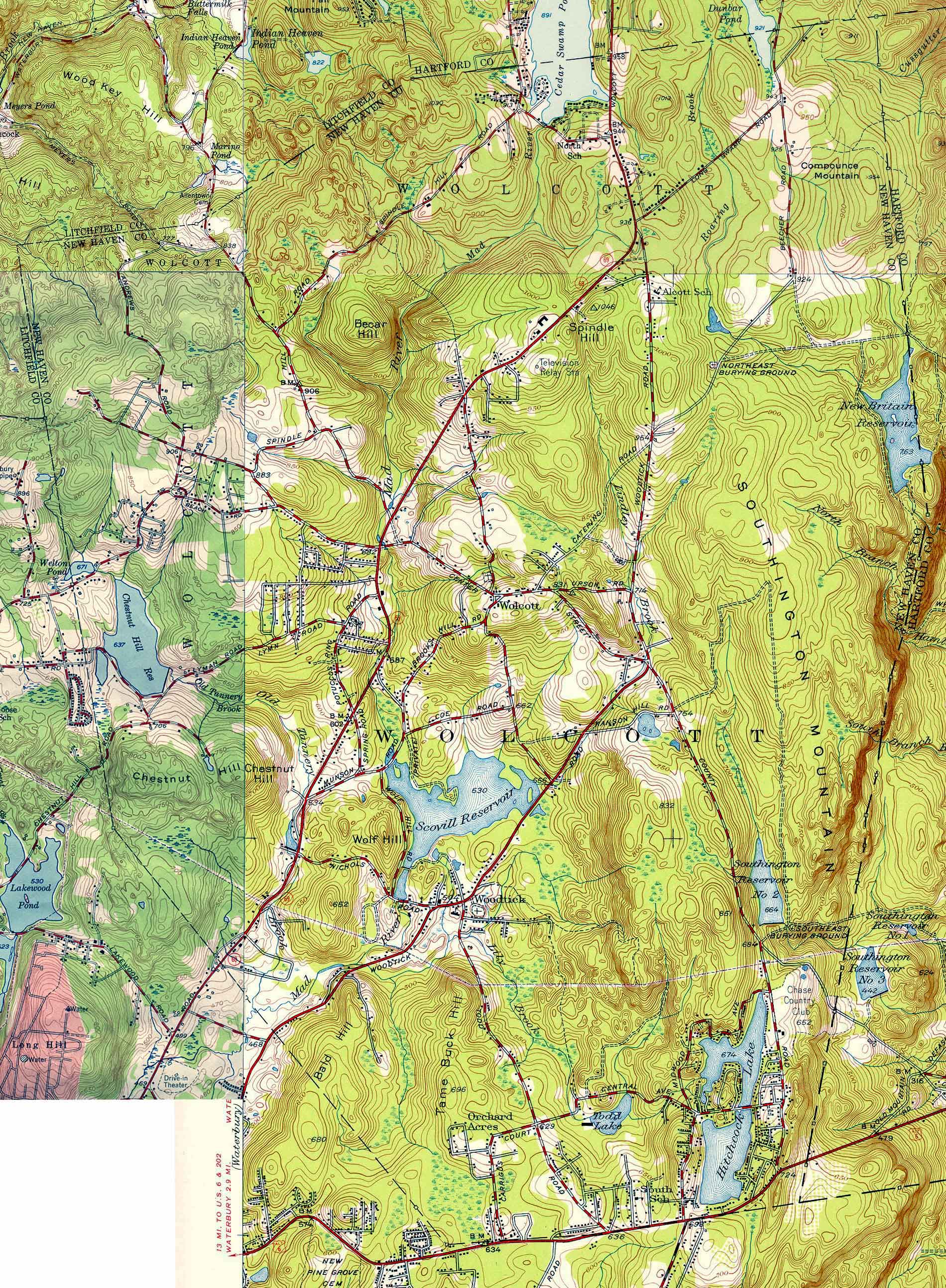
Wolcott is perched on the edge of this area, with a large drop in elevation (an escarpment) defining the eastern border of the town. There are no roads which travel down this escarpment, the only routes being one to the north which goes down a steep hill into Bristol and another being just below the southern end of town which goes down a steep hill into Southington. You can clearly see this drop-off in a geological map from the 1950s (*1).
The northern part of the town has higher elevations, with several hills exceeding 1000 ft. So, even within the town, there are distinct areas.
Except for a few streams which flow from the NE corner into Bristol and a few which flow down the escarpment on the east, the only significant waterway is the Mad River. It and its various tributaries cover the rest of the town (*2). There are no natural lakes, the only significant bodies of water being man-made through various dams which were constructed to hold water for use in power generation at other cities farther down these streams/rivers (*3).
In the below map of the state, you can see this sharp boundary of the escarpment as the color change just to the NE of the first “C” in Connecticut. The two lakes in this area are Scovill Reservoir and Hitchcock Lake which I address below.
[Map of Connecticut]

Impact on when the town was founded
In the days of colonial New England, the date of founding of most towns/cities was based on the availability of transportation. And transportation was impacted most by the use of water transportation. Thus, most new settlements began near, or at least close to, navigable water, especially the southern coast and the areas along the Connecticut River. Thus, the first cities/town in CT were founded in places like Hartford (1635), New Haven (1638), Milford (1639), Middletown (1651), Farmington (1645), and New London (1646), etc. Later, additional towns/cities sprang up along the smaller rivers in places like Wallingford (1670), Waterbury (1686), Danbury (1687), etc. These initial towns covered large geographic areas, and over the years were carved up into smaller pieces with the creation of other towns. For a complete list see (*4).
But Wolcott, being isolated by geography, was not a part of all this settlement. It was not until places like Hartford and New Haven were approaching their centennial year that the first individuals settled in town with the arrival of John Alcox and his family in 1731. While the area had been surveyed and lots defined, they were all owned by people who lived elsewhere. The town straddled the border between Farmington to the east and north and Waterbury to the west and south and was, appropriately, called Farmingbury. But it was empty of human inhabitants. Even the Native Americans did not live there. There was a trail which traversed the NW part of town, but that only served to connect the main Tunxis settlement in Farmington with a smaller one called Mattatuck (which became part of Waterbury) (*5).
Geographic features delayed settlement of the area for nearly 100 years. These same factors made for slow growth. The inhabitants were mostly farmers who belonged to the church in Waterbury. Since travel to Waterbury was difficult over dirt roads, they petitioned to have their own parish in 1770, which was granted. But requests to have their own town were continually turned down for the next several decades due to the small population. It was not until 1796 that the town was incorporated (and renamed Wolcott) and got its independence from Waterbury and Southington (which had split off of Farmington in 1779). The population of Wolcott at the time was slightly smaller than 1000 (*6).
Impact on lack of industry
Water is not only a means of navigation, but a source of power for industry as well. The Mad River is only large enough to provide power in the portion below the area around Center Street after several tributary streams have merged with it. Much of the early water-powered industry was for local consumption with things like flour mills or saw mills. But there was one attempt at something with more far-reaching impact.
Seth Thomas, one of the more famous people born in Wolcott (back when it was still called Farmingbury), began making clocks at a factory along the Mad River near the current intersection of Route 69 and Center Street in the early 1800s (*6). But because clocks have a market far beyond local farmers, he needed access to a larger population, so a few years later he asked the town fathers if they could construct a road between Wolcott and Cheshire to the southeast. (Cheshire had been split off of Wallingford in 1780 and there was good transportation from there down to the coast and thence to the larger markets in NY, etc.) The town fathers refused. In 1807, Seth closed his nascent business in Wolcott, went to work for Eli Terry (after whom Terryville is named), then bought out Terry’s factory, then bought out Heman Clark’s clock factory in Plymouth Hollow. These factories were on the Naugatuck river and thus had access to the larger markets he needed. In 1865, Plymouth Hollow was renamed Thomaston in his honor.
There were no other significant businesses the size of what the Seth Thomas factory became for many generations because of lack of easy access to larger markets. Even the water power from the Mad River was given away. The town fathers sold rights to out-of-town companies for the creation of dams and construction of lakes so that the water power could be used downstream. Beginning around 1860 and continuing through 1917, Hitchcock Lake, Scovill Reservoir, and Cedar Lake were created for use at mills in Waterbury, and the Southington and New Britain Reservoirs were created for water use in those respective cities.
Impact on population growth
Because of its geographic isolation, the population of the
town began a slow decline, from its high in 1810 (952) to fewer than 500 (491)
in 1870. It did not reach 1000 in population again until 1930 (*6). It was
during this period that the water rights in town were sold off. While the Mad
River dams were only for keeping water to be used to power industrial plants
downstream, the watersheds of the reservoirs were also cleared of homes and
roads, leaving the vast stretch on the top of the escarpment void of human
habitation.
Impact on identity and connectedness
By the mid-1930s, with the town approaching its 150th anniversary, the town was no larger than it had been at the beginning of the period. The only roads in town were dirt or gravel, making travel slow and dirty. The school system was all regionalized with individual one- or two-room schools in each part of town. The town was not large enough to have its own post office or phone exchange. Thus, the northern portion of the town got those services from Bristol (RFD mail and LU-dlow phone numbers). And the southern portion got similar services from Waterbury (with PL-aza phone numbers). It was a long-distance phone call from one part of town to the other – even in cases where you could see the house on the other side of the separating line.
So, people in the north identified with Bristol and, if they were employed outside of farming, worked in the clock factories in Bristol. Those in the south similarly identified with Waterbury and often worked in the brass mills there. Because there were no roads which descended the steep escarpment to the east, there was little connectedness with Southington. And with the main roads being north-south roads, there was similarly little connectedness with Plymouth to the NW.
In 1935, a major event happened which finally began to change this isolation. A new road was constructed through the town that connected Waterbury to Bristol – called appropriately the Waterbury-Bristol Road initially (later becoming known as Wolcott Road or Route 69 once Wolcott grew large enough). (It was probably funded through the federal government’s WPA program, although I have not been able to verify that.) And, even more significantly, it was paved – the first such road in Wolcott. A significant feature of this new road was a long straight stretch up the hill north of Center Street that gave quick access to the northern part of the town.
Travel across the town was now quick for the first time. And with quicker travel came population growth, especially after WWII when all the GIs came home from the war and were looking to settle down and start families.
My father was one of these GIs. He got married and bought 23
acres in the extreme northern end of town but was still working at his pre-war
job in Waterbury – 7 miles away. A new multi-room school was being built a
short distance away to support this surge in growth. But even in the late 40s,
my father used to say that there were many days that he did not see another car
on the road until he reached Waterbury. But the path had been laid, and it was
not too many years before the traffic greatly increased to the opening up of
the town through this simple act of building a new road that lowered the geographic
barriers (with the exception of the escarpment still remaining on the east side
of town).
Impact on ancestry
Most of the early cities/town in CT started small. Even Hartford, the capital of the Connecticut Colony, only had 163 families in 1640. So, availability of marriageable partners was somewhat limited and there were often multiple such marriages between these families. This practice is called endogamy and I have documented some instances in my family tree (*7). As new towns were settled, the new settlers were often from multiple other towns, but those from any one supplying town were likely related to others from that town and the new composite town would give new opportunities for marriage between individuals from the first set of towns. Thus, over time, many people in town would have some sort of family connection to many other people in that town.
The first generation of towns were places like Hartford (1635)
and New Haven (1637). The second generation of towns were places like
Wallingford (1670) and Waterbury (1686). Wolcott is representative of the third
generation of towns. I have previously listed some of my ancestors from some of
these, including Hartford (*8), Wallingford (*9), and Waterbury (*10) where I
have ancestral/cousin relationships with a large percentage of the early
residents. But this will also be true of nearly anyone who has such deep roots
in colonial New England. Wolcott and other third generation towns will likely
have the highest percentage of such ancestral connections because they were
products of the endogamy of each of the preceding generations of new, small
towns.
Conclusion
Many small towns have some of the above features. But the
geography of Wolcott, with the barrier of the escarpment to the east and lack
of navigable waters contributed greatly to the history of the town. However,
this also made it an ideal place for me to grow up in the 1950s and 1960s. I
couldn’t have asked for any place better!
Notes:
*1 - https://web.tapr.org/~wa1lou/whs/wlct535556A.jpg
*2 - https://ramblinrussells.blogspot.com/2015/09/wolcott-history-rivers-and-brooks.html
*3 - https://ramblinrussells.blogspot.com/2015/09/wolcott-history-lakes-and-ponds.html
*4 - https://ctstatelibrary.org/cttowns/counties
*5 - https://ramblinrussells.blogspot.com/2015/07/wolcott-history-indians.html
*6 - https://ramblinrussells.blogspot.com/2015/04/wolcott-history-chronology-of-wolcott.html
*7 - https://ramblinrussells.blogspot.com/2019/04/endogamy-consanguinity-and-nepotism-in.html
*8 - https://ramblinrussells.blogspot.com/2020/11/founders-of-hartford.html
*9 - https://ramblinrussells.blogspot.com/2018/09/wallingford-connections.html
*10 - https://ramblinrussells.blogspot.com/2018/09/waterbury-first-families.html
I was born in 1934 at the Waterbury Hospital (as was my brother, two years earlier), and my parents lived along Spindle Hill Road, just north of Peterson's Farm and on land acquired from our Uncle and Aunt, Carl and Hilma Peterson. Our mailing address was a Terryville PO route (not Waterbury or Bristol), and I remember one snowy winter walking with my mother and brother to the Terryville PO for the mail that could not be delivered because of the snow. My parents first house was the "Seth Thomas" (or "Alcott") house just south of the Peterson's Farm house -- they agreed to try to restore that Seth Thomas house to liveable condition, rent free, since that house had been unoccupied for a period of time. Then they purchased the lot to the north and built a new house there, in or about 1934 (I never lived in the Seth Thomas house, but my brother did). Other relevant memories: telephone party line (I forget the number), bus transportation along route 69 (my brother and I went in to Waterbury to see movies at the Plaza Theater on occasion, and we helped Mom at Mackormicks snack stand as noted earlier on the FB page), school bussing to New Woodtick, then to Old Woodtick, then to North, and finally to Crosby HS in Waterbury, sledding in the fields (and baseball), etc. Great place to grow up!!
ReplyDeleteThis is very interesting - I learned that through my Andrews relatives I am descended from Hartford, New Haven and Wallingford families. I figured people traveled on the river, but your map and discussion makes it clear. Thank you very much. (My Andrews' moved to Sheffield MA and then on to Chili Monroe County NY). I do wonder why “20 men” went from Cambridge MA to settle Hartford as they did not have a direct river route.
ReplyDelete