Tuesday, December 1, 2020

Wolcott History – Learnings from the 1870 Census

In my writings about Wolcott history over the years, I’ve mentioned the 1870 Federal Census a couple of times. In (*1), I noted that 1870 was the low point in the population of the town. My words there were:

From its high in 1810 (952), the population of the town began a slow decline, eventually bottoming out at fewer than 500 (491) in 1870. It did not reach 1000 in population again until 1930.

And in (*2), I was exploring the roots of my grandfather’s step-mother, Anna [Root] [Hall] Pierpont, who was a school teacher in Wolcott in 1870. I’ll touch on this more below.

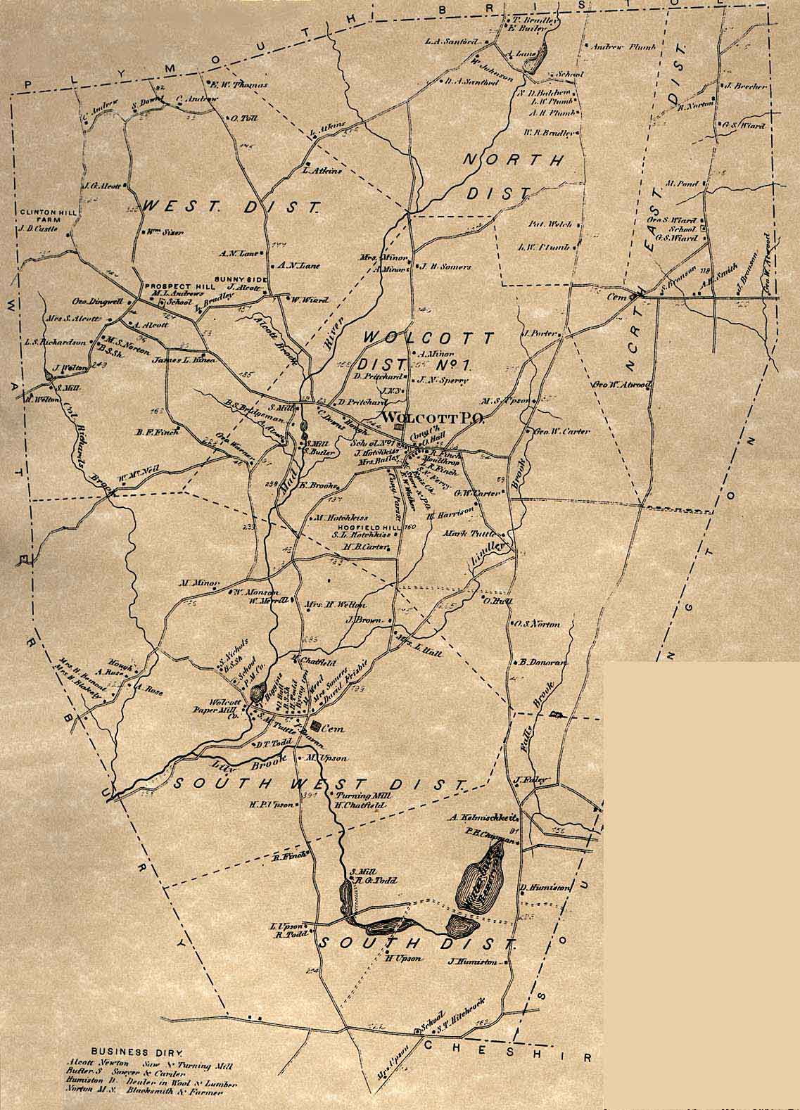
But because of the availability of a map of the town that is posted on the wolcotthistory.org website (*3), we have a unique opportunity to look at the geography of the census. And we can use this to explore a couple of questions that some others have had about the town’s history at the time. I’ll bring those up as appropriate below.

[1868 Map]


How the Census Was Taken

Unlike today’s Federal Census, where every household receives a form in the mail that can be filled out and either mailed or submitted online, the census in times past was done by a census taker visiting each home in-person, interviewing the head of household or their spouse, and filling in the appropriate line on the census form. The person who was the census taker for Wolcott in 1870 was a man named Sturgis Judd. He was 61 and lived in Waterbury with his wife and 25yo daughter who was a milliner. His primary occupation was that of “Collector of Bills”, but for two months in the summer of 1870 he worked full-time taking the census. Beginning on June 1st, he and one other man took the census for the entire city of Waterbury. Sturgis did 2/3 of the homes (about 10,000 residents in over 1300 dwellings). He finished this task in mid-July, signed the last page (he had completed 227 pages of the 333 that it took to record everyone in Waterbury), then immediately moved on to taking the Wolcott census.

Having done 1300 dwellings in 6 weeks, and with only 120 dwellings in Wolcott, he may have thought that Wolcott would only take a few days, but since all the roads in Wolcott were unpaved and the houses often far apart, it took him most of a week to finish tabulating the 491 names in the Wolcott census.

Sturgis was very thorough in his work, noting for each person their name, age, gender, race, occupation, and all the other information required. A few interesting statistics from my analysis:

·       490 were “W”hite, there was only one “M”ulatto (colored) farm laborer

·       Nearly all occupations were “farmer,” “keeping house,”, “at home” (young children), “at school,” or “farm laborer”. Some of the other “occupations” were domestic servant (4), clergyman (1), school teacher (3) (more on this below), tanner (2), and about 10 or so miscellaneous occupations.

Working the way around the town

Because of the availability of the map from just two years earlier, it was easy to match the family names from the census with the names associated with each home and plot the path that Sturgis took around town. Note in the below that I am using the names of current day Wolcott roads, I am not sure what the names were back then.

He began in the SW corner of the town on what is now Meriden Road, the first home being that of Sheldon Hitchcock. He then went up Todd Road as far as Central Ave, then across Central Ave to East Street, and up East Street/County Road. This covered all seven families in the South School District. Here is the first part of page one of the census as an example.

[First part of page 1 of 1870 census]


Continuing up County Road, then Woodtick Road as far as Catering Road, he visited 9 families in the Central School District. He then went in Beecher Road, going down the road that led to where the New Britain reservoir is today, then back and up the rest of Beecher Road as far as the Norton Farm. This covered all 9 families in the North East School District. Here, Sturgis ran out of time on that Thursday, 7/14. I’m not sure whether he went back to Waterbury for the night or found a family to stay with for the night. At any rate, he would have had to back track all the way down Beecher Road to Woodtick Road as Long Swamp Road did not yet exist.

Starting off on Friday, 7/15, Sturgis began back north on Woodtick Road, then continuing north on Route 69. Then he went in North Street to Spindle Hill Road, going slightly north on that road as far as the Bristol line, then back south. All 17 families here would be in the North School District. Continuing on Spindle Hill Road, Andrews Road and other side roads, and ending up on Lyman Road, he visited all 22 families in the West School District before once again running out of daylight.

On Saturday, 7/16, Sturgis began by continuing on Potuccos Ring Road to Route 69 as far as Center Street, then up to the center of town and visiting families there and on Bound Line Road, visiting a total of 23 families in the Center School District. He ended up at the home of the pastor of the Congregational Church, Warren Finch. There was no census taking on Sunday.

On Monday, 7/18 Sturgis began by going down Brooks Hill Road (the first family being the Brooks family after whom the road is named), covering the last 3 families in the Center School District and then making his way down toward Woodtick Road visiting 10 families in the South West School District.

Finally, on Tuesday, 7/19, Sturgis finished the remaining homes in the Woodtick/Todd Road area, then went down Woodtick Road back to Waterbury, visiting the last 20 homes in the South West School District.

It was a long five days, plus a day of rest on Sunday, of going to every home in Wolcott! But the record of all his visits is preserved in Sturgis’ excellent handwriting for us to see 150 years later.

Schools in Wolcott

I was asked recently if I thought that the entire network of one-room schools that had originally been established continued through the decline in population. Although the 1868 map shows six school buildings, were they all used, or were schools combined?

Before answering that question, a few words about schools in the mid-1800s are in order.

While compulsory education was not legislated in Connecticut until 1872, most people were already going to school in 1870. Local schools were often one-room schools which only served the elementary years (grades 1-8) with high schools only available in larger cities and students going on to “higher” education boarding nearby. Teachers were required to be unmarried and were nearly all female. They were generally in their late-teens or early-20s (the only requirement being that they had already finished elementary school). If they did not live nearby (often the case), then they boarded with a local family.

Such was the situation in Wolcott. All the students noted as being “at school” were between age 7 and 14/15 (remember that school began in grade 1, there was no kindergarten, and ended after grade 8). There were 91 such students among the 491 residents and there were three teachers in the census. The distribution of students among the six school districts noted on the 1868 map was as follows: N-14, NE-8, W-19, C-24, SW-20, S-6.

There were three teachers in the census. In the North East District was Anna Root, age 17, who was boarding with the family of George Atwood (who had one child of school age). As I had noted in (*2), Anna’s home was in the Woodtick area of town, but she travelled north to the Atwood home at the beginning of each week and then returned home on Friday after school – it being too far to make the daily commute to the North East school.

In the West District was Ella Crandal, age 22. She was from Hartford, and she was boarding with the Richardson family about 5 houses away from the West District school. In the Center District was Sarah Finch, age 25. She was the daughter of the town clergyman and lived right across the green from the Center School. But what about the other three schools?

I suspect the North District school was served by a teacher who lived in Bristol as it was so close to that much larger town. But with 14 students, it was certainly large enough to continue. Similarly, the South District school was served by a teacher from Waterbury as it was right on Meriden Road which was the border of Waterbury.

For the large South West District school, there are two possibilities. One is that the teacher lived in Waterbury and commuted up Woodtick Road each day. I recall seeing information about individuals who made that commute in the past. But the other possibility is related to the timing of the census.

When Sturgis Judd began taking the census, it was Thursday, July 14. When visiting the home of George Atwood, Anna Root was noted as living there – it being a school day when she would have been boarding. But by the time he visited the Root family home in the Woodtick area in the late afternoon of Monday, July 18, Anna was there instead and had the distinction of being counted twice in the same census. I suspect that Friday, July 15, was the last day of the school term, so that by the following Monday, Anna was back home as July 18 was no longer a school day. Since she was back home, then the teacher who had been boarding in the Woodtick area would have also finished for the term and she similarly would not have been counted in the census as she would have returned home (possibly to Waterbury). So, whether the South West teacher was commuting from elsewhere, or whether she was no longer boarding in the area due to the timing of the census, we have a logical explanation of why she was not counted in the 1870 census. In the latter case, Anna Root being counted twice just made up for the South West teacher being missed in the census.

The Two-Home Problem

If you study the 1868 map closely, you will note that there are three instances where there are two dots listed with the same name. Two of the instances are on Spindle Hill Road in the West School District – the two occurrences of Albert N. Lane, and the two occurrences of Levi Atkins (one in the West District and one just over the border in the North District). The other occurrence is in the North East District where George W. Atwood appears twice – once on the E-W road near the eastern edge of town, and once on the N-S road that goes down toward where the Southington Reservoir is currently located.

Most farms of this era, and Wolcott was nearly all a farming community, would have had a building complex – the main farm house where the family lived, one or more barns that held animals, hay, or other farm equipment, and possibly other smaller outbuilding for storage purposes as well. In any case there would have been only a single small dot on the map needed to identify the location of this complex of buildings and the owner of that complex.

But what about a situation where a large farm has additional fields located away from the main complex? If there were additional buildings associated with these additional fields, how would one know when driving past them who they belonged to? I believe that is the case here. Note that for both Albert Lane and Levi Atkins, that the second dot on the map is not only down the road a bit, but that it is on the opposite side of the road. In order for anyone using the map to know who to contact regarding that isolated building, they can see the presence of another building farther up the road with the same owner.

The situation with George Atwood is a little more complicated. We can be pretty certain that George and his family lived in the home at the eastern boundary of the town. That’s because when Sturgis Judd was visiting each home taking the census, he went to the homes of Stillman Bronson and Anson Smith before going to the homes farther down the road – George Atwood and Jarvis Bronson. Then he went to the George Wiand home up on Beecher Road near the North East School next. This visit order is pretty good confirmation of which dot on the map represents the home where the Atwood family lived (and which is close enough to the school that it would have been a logical place for Anna Root to board during the week).

[George Atwood map]


The N-S road heading down toward the current Southington Reservoir was already abandoned by 1868. Although there had been several homes there in the late 1700s, the farms had all been abandoned and no one lived there anymore. It remains an abandoned road to this day, although it is still open to hiking and the CT Blue Trails uses a portion of the northern part of it. But in 1868 there was still one active building on the west side of the road – apparently a barn that was owned by George Atwood who was trying to farm one of the still existent fields that he had purchased along with the ones around his house. It’s possible that this barn is what my cousin Rob saw on a recent hike as all that remains is a 20’ wide foundation right alongside the road.

Conclusion

The availability of this old map that is only two years removed from the 1870 census of Wolcott has made this analysis all possible. I’m grateful for the Wolcott Historical Society for preserving these artifacts from the town’s past, as well as for the current technology that makes things like scanned images of century-old census records available via the Internet. Doing historical research from the comfort of one’s home is so much easier than having to visit a library that might have such things on microfilm.

Notes:

*1 - https://ramblinrussells.blogspot.com/2015/04/wolcott-history-chronology-of-wolcott.html

*2 - https://ramblinrussells.blogspot.com/2017/12/genealogy-story-tangled-wolcott-web.html

*3 - https://web.tapr.org/~wa1lou/whs/1868mapA.jpg


Tuesday, November 24, 2020

Deep Connecticut Roots

The settlement of colonial Connecticut began in earnest is the mid-1630s with groups traveling from the Massachusetts Bay Colony either overland to the Connecticut River Valley and places like Wethersfield and Hartford, or via ship along the coast to places like New Haven and Milford. In each of these groups there were a number who were my ancestors. While the migration from England known as the Great Migration ended somewhat abruptly in 1640 with the outbreak of the civil war there, the spreading of the colonists to other new cities and towns, both along the Connecticut River and along Long Island Sound continued.

I had always thought of my ancestors being from New Haven as my mother’s maiden name was Pierpont and the Pierpont family is centered there due to Rev. James Pierpont who became the pastor of the Congregational Church in the late 1600s. Although he was from Boston and received his education at Harvard, he was very well connected and through marriages of his and his descendants established lineages with many other Connecticut families. My father’s family was originally from Dutchess County, NY, but they had also married into a number of CT families.

So, when there was a recent Facebook posting about the founders of Hartford and I decided to see which of them were in my family tree, I was somewhat surprised to discover that about a quarter of them are my ancestors (*1). I was able to do this because I spent several weeks last year tracing back all my family lines to the original immigrant families so I could simply do name searches for each of the Hartford founders to see if they were in my tree. I still have quite a few roadblocks and a number of relationships that I don’t totally trust, but I’m pretty sure of most of my research (*2).

Recently, there are been a number of postings in another Facebook forum about ancestors from other Connecticut cities/towns and I’ve been wondering if I would have similar success there. There is a list in (*3) that shows the founding date of each city/town in the state, so I have undertaken a quest to go through the early cities. I’ve used the first 20 years of founding dates, i.e. 1633-1653 as the cutoff as there are 14 on that list and then a gap until later settlements.

Below are the overall results as well as the details for the other 13 cities/town in alphabetical order. I am astounded at how deep and broad my Connecticut genealogical roots are!

A few notes on the below. First, the number of founders of each place is sometimes subject to interpretation. For some there are multiple sources which quote different figures. I have not tried to reconcile these disparate figures, but have used the references that seem to have the most inclusive list of individuals. Second, there are sometimes different spellings for a person’s name. This is fairly common in colonial times and especially vowel substitution makes genealogical research challenging. Third, I’ve used the following notations in the detail list: (a) g9gf means great*9 grandfather; (b) I’ve marked with an “*” those who are ancestors of my wife who has some family lines back to CT, some of these are to the same individuals as my ancestors, some are in addition; and (c) the notation “(step)” refers to a few cases where a woman had multiple marriages, usually due to the death of a first husband, and while she is my direct ancestor, the individual listed as a founder is not the father of the child that led to me.

[Chart]


Notes:

*1 – https://ramblinrussells.blogspot.com/2020/11/founders-of-hartford.html

*2 – https://ramblinrussells.blogspot.com/2019/04/great-migration-ancestors.html

*3 – https://ctstatelibrary.org/cttowns/counties


Deep River (formerly Saybrook)

https://saybrookhistory.org/history-of-old-saybrook/

·       Lion Gardiner - *


Fairfield

https://www.ancestry.com/imageviewer/collections/16157/images/dvm_LocHist004103-00047-1?ssrc=&backlabel=Return

·       William Bateman – g9gf

·       James Bennett – g9gf

·       William Frost – g10gf

·       Henry Gray – g9gf

·       George Squire – g9gf

·       Thomas Staples – g10gf*

·       Benjamin Turney – g10gf

·       Ephraim Wheeler – g9gf

·       Thomas Wheeler – g10gf


Farmington

http://josfamilyhistory.com/locations/farmington-ct.htm#:~:text=Most%20of%20Farmington's%20first%20settlers,the%20new%20colony%2C%20such%20as

·       John Bronson – g8gf

·       William Hickox – g9gf

·       Thomas Orton – (step)g9gf

·       Thomas Upson – g8gf*

·       George Wyllys - *


Guilford

https://www.geni.com/projects/Original-Planters-Guilford-Connecticut-1639/1494

·       John Bishop – g11gf

·       Francis Bushnell – g11gf

·       William Dudley – g10gf

·       John Parmarly/Parmalee – g8gf


Middletown

http://www.middletown1650.org/Membership.html

·       John Hall – g9gf

·       Giles Hamlin – g8gf

·       George Hubbard – g10gf*

·       William Smith - *

·       Nathaniel White – g8gf


Milford

http://daneovideo.com/mhs-new/founders.php

·       Nathaniel Baldwin – g9gf

·       Timothy Baldwin – g9gf

·       Henry Botsford – g9gf

·       Nathaniel Briscoe – g9gf

·       John Burwell – (step)g9gf

·       Nicholas Camp – g10gf

·       George Clark – g9gf

·       Jasper Gunn – g10gf

·       John Lane – g9gf

·       Richard Miles – (step)g8gf

·       James Prudden – g11gf

·       Peter Prudden – g9gf

·       Micah Tomkins/Tompkins – g9gf

·       Thomas Wheeler – g10gf

·       Thomas Uffott/Ufford – g9gf


New Haven

https://www.geni.com/projects/Founders-of-the-New-Haven-Colony/30351

·       William Andrews – g10gf*

·       John Charles – g10gf

·       John Clark – g10gf

·       John Cooper – g9gf*

·       Jasper Crane – g10gf

·       Timothy Ford – g8gf

·       Matthew Gilbert – g9gf*

·       Matthias Hitchcock – *

·       William Ives – (step)g8gf

·       Andrew Messenger – g9gf

·       John Peacock – g10gf

·       William Potter – g8gf*

·       William Preston – g10gf

·       Robert Seeley – g10gf

·       George Smith – g9gf

·       Nathaniel Turner – g10gf

·       William Tuttle – g9gf

·       Thomas Yale – g9gf


New London

http://dunhamwilcox.net/town_hist/nl-chap11a.htm

·       George Chappell - *

·       Robert Isbell – g9gf

·       Thomas Stedman – g9gf


Norwalk

https://en.wikipedia.org/wiki/Category:Founding_settlers_of_Norwalk,_Connecticut

https://familypedia.wikia.org/wiki/Norwalk_1649_Founders_Stone

·       George Abbitt/Abbott – g9gf

·       Thomas Fitch – g9gf

·       John Gregory – g9gf

·       Ralph Keeler – g9gf

·       Daniel Kellogg – g8gf*

·       Thomas Lupton – g8gf

·       Matthew Marvin Sr – g11gf

·       John Ruscoe – g9gf


Stamford

https://www.ctgenweb.org/county/cofairfield/pages/stamford/settlers_page.htm

·       Francis Bell - *

·       Jeffrey Ferris - *

·       Joseph Garnsey – (step)g11gf

·       John Holly – g10gf

·       Francis Holmes – g11gf

·       Simon Hoyt – g9gf

·       Nicholas Knapp - *

·       Robert Lockwood – g8gf

·       Obadiah Seeley – g10gf

·       Henry Smith - *

·       John Waterbury – g11gf

·       Jonas Weed – g10gf*


Stratford

https://www.geni.com/projects/Founding-Families-of-Stratford-Connecticut/47320

·       Adam Blackman – g10gf

·       Richard Boothe – g10gf

·       John Curtis – g8gf*

·       Thomas Fairchild – g10gf

·       Henry Gregory – g10gf

·       Francis Hall – g9gf

·       Richard Harvey – g10gf

·       John Hurd – g9gf

·       Joseph Judson – g9gf

·       John Peacock – g10gf

·       Thomas Sherwood – g10gf

·       John Tompson/Thompson – g10gf

·       Thomas Ufford – g9gf

·       John Wells/Welles – g9gf*

·       William WIlcockson/WIlcockson – g10gf


Wethersfield

https://sites.google.com/a/oldconnecticutpath.com/oldconnecticutpath/home/5-founders-of-wethersfield

·       Robert Seeley – g10gf

·       Nathaniel Foote – g8gf


Windsor

http://tourwindsorct.org/historic/FoundersofWindsorM/

https://sites.google.com/a/oldconnecticutpath.com/oldconnecticutpath/home/4-founders-of-windsor

https://www.werelate.org/wiki/List_of_Founders_of_Windsor,_Connecticut

·       Matthew Allyn – g11gf

·       John Bartlett – *

·       William Buell – g10gf

·       Nicholas Denslow – g11gf

·       Thomas Dibble – g9gf

·       John Drake – *

·       John Hawkes – *

·       William Hulbert – *

·       Joseph Loomis – g10gf*

·       Thomas Newberry – g11gf

·       Thomas Newell – g9gf

·       Nicholas Palmer – g10gf

·       Thomas Parsons – g9gf

·       William Phelps – g10gf

·       Eltweed Pomeroy – (step)g9gf

·       Samuel Pond – g9gf

·       John Porter – g10gf

·       John Taylor – g10gf

·       Richard Vore – g10gf


Wednesday, November 18, 2020

Wolcott History – Echoes of Farmingbury

Many readers of my various blogs about Wolcott will know that the town was known as Farmingbury before it was incorporated and recognized by the State of Connecticut in 1796 and was then renamed Wolcott in honor of Lt. Governor Oliver Wolcott who cast the deciding vote in favor of that incorporation. But what was the basis of it being named Farmingbury, and can we still see any of the residual of the decisions that had been made prior to 1796? Through the use of a number of maps, I’d like to explore that question.


Connecticut Town Formation

In the early days of the Colony of Connecticut and then the State of Connecticut following the Revolutionary War, the towns/cities were fairly large geographic areas. The below partial map of the state from around that time shows the area immediately around what is now Wolcott (*1).

[Map from 1776]


Let’s look at just two of these towns, Farmington and Waterbury. Farmington is roughly rectangular and occupies the entire area west of Hartford and Wethersfield. There are a few villages within the town, including New Cambridge (later to be renamed Bristol), and Southington (an abbreviation for South Farmington). Waterbury also occupies a much larger area than it does now. It includes the villages of North Bury, West Bury, and Salem. Note also that the river that runs up that valley is called the Waterbury River – it later was renamed as the Naugatuck River.

Farmingbury is too small a place to be noted on the map.

Now let’s look at a newer map of roughly the same area from the present day (*2).

[Map from 2020]


Based on the dates in (*3), the following towns have been carved out of Farmington: Southington (1779), Bristol (1785), most of Berlin (1785), Burlington (1806 from Bristol), Avon (1830), New Britain (1850 from Berlin), and Plainville (1869). Similarly, Waterbury has been broken up into: Watertown (1780), Plymouth (1795 from Watertown), Middlebury (1807), part of Prospect (1827), Naugatuck (1844), and Thomaston (1875 from Plymouth),

Wolcott was carved out of both Waterbury and Farmington (actually from Southington). Although Wolcott was not incorporated until 1796, the first petition to do so was several years earlier. The timing here is likely some of the reason why the first few attempts were not approved and why even the 1796 petition met with resistance.

In 1787, the only town which had split off of Waterbury was Watertown and that had only happened a few years earlier. Similarly, the only splits from Farmington had been Southington and Bristol. All of these had also been of much larger populations. Farmingbury was not only a very small community, but by spanning the border of New Haven and Hartford counties, they were disrupting things in a significant way, i.e. it was not just carving off a piece of one town, but carving off sections of two towns in two different counties. That they were ultimately successful in doing so is a tribute to their tenacity as well as the assistance of the Lt. Governor who cast the tie-breaking vote in the State Senate.

Residual Features

The below maps are all snipped from a “parcel viewer” from the Wolcott Assessors office (*4).

The border between the Waterbury portion and the Farmington portion of Farmingbury is the “bound line”. I have discussed that earlier in (*5). The land to the east of the “bound line” was laid out in long lots.  Orcutt, in his seminal book, “History of the Town of Wolcott (Connecticut) from 1731 to 1874, with an account of the Centenary Meeting, September 10th and 11th 1873; and with the Genealogies of the Families of the Town” describes it as follows:

The Farmington part was laid into "long lots," being in three tiers, of one mile each. The first tier joined Waterbury, or the "bound line," the second lay east of the first, and the third east of the second, extending to the foot of Southington Mountain. The whole length of each "long lot" is said (in some of the deeds) to have been three miles. The lots were numbered from north to south, and must have commenced near the northern boundary of Wolcott.

But can we find evidence of all of this today? The answer is a resounding yes! Let’s look at a number of examples. First, let’s look at an overview of the entire area.

[Parcels – overview]


You can see in this picture the western boundary of Hartford County (the former boundary of all of Farmington). The roughly North-to-South line enters Wolcott at the jog in the northern boundary of the town and proceeds down to the southern edge of town. Let’s zoom in and look a little closer at this boundary line.

[Parcels – town overview]


Here you can still see the residual of this former county line. It’s clearly visible in the edge of properties in the middle part of the town in the northern section, fades out near Center Street, then reappears a little fainter in the area below Scovill Reservoir. Also note (1) the presence of another parallel north-to-south line spaced a bit to the east of the bound line (comprised of Route 69, Woodtick Road, County Road, and East Street in the southern end. There are also some large rectangular pieces of property in the NE part of town. Let’s zoom in on several of these features.

[Parcels – NE]


Looking at the NE part of town we can clearly see the remains of several of the “long lots” that were a part of the original Farmington/Farmingbury, even in the part of town to the west of Route 69. Also note the parallel lines – the leftmost one being the residual of the bound line border of the two counties now only viewable in property lines, the center one being Route 69 north of Woodtick Road, another one farther east being Beecher Road, and the border of Wolcott being on the eastern edge of this picture. The blue line which traces property lines from the former Bound Line Road to the intersection of Route 69 and Woodtick Road is exactly one mile in length!

[Parcel – SE]


Here we have a similar portion of town near Hitchcock Lake. Again, note that there are several property lines running at the same angle (a right angle to the former Bound Line Road. Bound Line Road here no longer exists by that name, but one residual that remains is the jog in Central Ave. Again, the blue line from that jog to East Street is exactly one mile in length!

[Parcels – NE cemeteries]


Finally, I want to zoom in one final feature. Here we see a wooded section near the Wilson Road intersection with Woodtick Road. Woodtick Road here is one mile east of Bound Line Road. The diagonal road on the east side of the map is a now closed part of Beecher Road and the road running to the east from it is part of the New Britain Reservoir property and runs all the way to the edge of Wolcott. The path in the woods and the road to the east form the edge of one of the “long lots”. The old Pike’s Hill Cemetery is about where the “N” along the path is located, and the old Northeast Burying Ground is right where the path comes out on Beecher Road.

[Parcels – Escarpment]


Before leaving these parcel views, I want to look at one final one which shows the complete eastern side of Wolcott. Here you can clearly see that the portion carved out of Farmington is a five-sided figure. The western edge is the former “bound line”. The northern edge is perpendicular to that edge and runs about 2.5 miles in an ENE direction. The eastern edge is parallel to the bound line and runs south until it runs into the escarpment which drops off into what is now Southington. It then jogs slightly to the right and follows the escarpment down to a point which meets the former southern edge of Hartford County, then it turns back WSW to the southern end of the “bound line”.

Thus, we see from Farmington’s (Southington’s) perspective, it was a “carve out” defined by a combination of county edges and a geographic feature of the uncrossable escarpment.

Conclusion

The history of the town of Wolcott is a composite of many factors. The shape of the town was dictated by a combination of geography (an escarpment which was nearly uncrossable by roads), the decision by early colonial settlers at defining county boundaries, timing (when the town fathers requested that the town be founded relative to other towns being carved out of the larger ones), and politics (the tie-breaking vote by Lt. Governor Oliver Wolcott).

It is now over 200 years later, with the 225th anniversary of the town just a month or so away. And we can still see some of the residuals of that long-ago time in lot lines, major roads (both their direction and distances between them) which ran along the edges of lot lines, and even the location of some of the cemeteries (which were also located on the edges of lot lines – all features that may be imperceptible unless you look at a high-above overview of these features!

Many things have changed over the years with new roads, subdivisions, etc. reshaping the town. But the echoes of those long ago times still resound in many ways.

Notes:

*1 - https://www.flickr.com/photos/uconnlibrariesmagic/3332887013/in/set-72157617878169122/

*2 - https://jud.ct.gov/ADA/ct_map.htm

*3 - https://ctstatelibrary.org/cttowns/counties

*4 - https://wolcott.maps.arcgis.com/apps/webappviewer/index.html?id=e22cf98e70004152ae7dfbecdeabc769

*5 - https://ramblinrussells.blogspot.com/2015/04/wolcott-history-farmingbury-part-1.html


Saturday, November 14, 2020

How Geography Affected Wolcott Growth

There are some geographic features about my hometown of Wolcott, CT which have had a major impact on its growth over the years. This is an attempt to identify some of that impact.


Synopsis of Wolcott geography

Connecticut, although not a large state, has several distinct geographic/topological features that break it up into different areas. The southern border of the state is defined by the Long Island Sound and this sheltered body of water provides easy salt-water access to that part of the state. The center of the state contains the Connecticut River which traverses the state in a general north-to-south direction and the broad river valley with rich soil is easily able to be traversed and planted. There are also a number of smaller rivers (Housatonic, Naugatuck, Quinnipiac, Thames, etc.) which also provide water travel to other parts of the state. The NW portion of the state is quite elevated and is sometimes called the Litchfield Hills, or the foothills of the Berkshires.

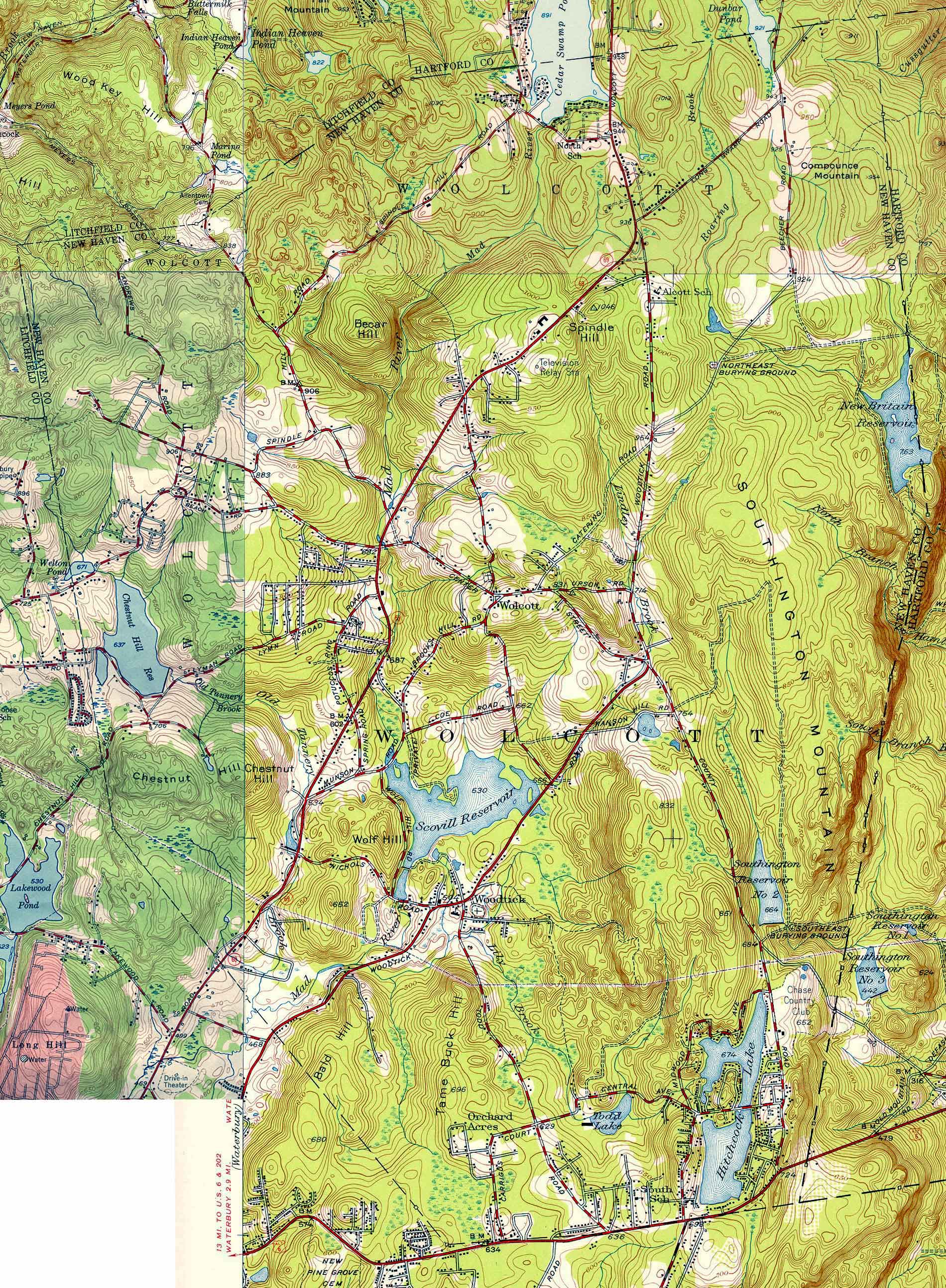
Wolcott is perched on the edge of this area, with a large drop in elevation (an escarpment) defining the eastern border of the town. There are no roads which travel down this escarpment, the only routes being one to the north which goes down a steep hill into Bristol and another being just below the southern end of town which goes down a steep hill into Southington. You can clearly see this drop-off in a geological map from the 1950s (*1).

The northern part of the town has higher elevations, with several hills exceeding 1000 ft. So, even within the town, there are distinct areas.

Except for a few streams which flow from the NE corner into Bristol and a few which flow down the escarpment on the east, the only significant waterway is the Mad River. It and its various tributaries cover the rest of the town (*2). There are no natural lakes, the only significant bodies of water being man-made through various dams which were constructed to hold water for use in power generation at other cities farther down these streams/rivers (*3).

In the below map of the state, you can see this sharp boundary of the escarpment as the color change just to the NE of the first “C” in Connecticut. The two lakes in this area are Scovill Reservoir and Hitchcock Lake which I address below.

[Map of Connecticut]


Impact on when the town was founded

In the days of colonial New England, the date of founding of most towns/cities was based on the availability of transportation. And transportation was impacted most by the use of water transportation. Thus, most new settlements began near, or at least close to, navigable water, especially the southern coast and the areas along the Connecticut River. Thus, the first cities/town in CT were founded in places like Hartford (1635), New Haven (1638), Milford (1639), Middletown (1651), Farmington (1645), and New London (1646), etc. Later, additional towns/cities sprang up along the smaller rivers in places like Wallingford (1670), Waterbury (1686), Danbury (1687), etc. These initial towns covered large geographic areas, and over the years were carved up into smaller pieces with the creation of other towns. For a complete list see (*4).

But Wolcott, being isolated by geography, was not a part of all this settlement. It was not until places like Hartford and New Haven were approaching their centennial year that the first individuals settled in town with the arrival of John Alcox and his family in 1731. While the area had been surveyed and lots defined, they were all owned by people who lived elsewhere. The town straddled the border between Farmington to the east and north and Waterbury to the west and south and was, appropriately, called Farmingbury. But it was empty of human inhabitants. Even the Native Americans did not live there. There was a trail which traversed the NW part of town, but that only served to connect the main Tunxis settlement in Farmington with a smaller one called Mattatuck (which became part of Waterbury) (*5).

Geographic features delayed settlement of the area for nearly 100 years. These same factors made for slow growth. The inhabitants were mostly farmers who belonged to the church in Waterbury. Since travel to Waterbury was difficult over dirt roads, they petitioned to have their own parish in 1770, which was granted. But requests to have their own town were continually turned down for the next several decades due to the small population. It was not until 1796 that the town was incorporated (and renamed Wolcott) and got its independence from Waterbury and Southington (which had split off of Farmington in 1779). The population of Wolcott at the time was slightly smaller than 1000 (*6).


Impact on lack of industry

Water is not only a means of navigation, but a source of power for industry as well. The Mad River is only large enough to provide power in the portion below the area around Center Street after several tributary streams have merged with it. Much of the early water-powered industry was for local consumption with things like flour mills or saw mills. But there was one attempt at something with more far-reaching impact.

Seth Thomas, one of the more famous people born in Wolcott (back when it was still called Farmingbury), began making clocks at a factory along the Mad River near the current intersection of Route 69 and Center Street in the early 1800s (*6). But because clocks have a market far beyond local farmers, he needed access to a larger population, so a few years later he asked the town fathers if they could construct a road between Wolcott and Cheshire to the southeast. (Cheshire had been split off of Wallingford in 1780 and there was good transportation from there down to the coast and thence to the larger markets in NY, etc.) The town fathers refused. In 1807, Seth closed his nascent business in Wolcott, went to work for Eli Terry (after whom Terryville is named), then bought out Terry’s factory, then bought out Heman Clark’s clock factory in Plymouth Hollow. These factories were on the Naugatuck river and thus had access to the larger markets he needed. In 1865, Plymouth Hollow was renamed Thomaston in his honor.

There were no other significant businesses the size of what the Seth Thomas factory became for many generations because of lack of easy access to larger markets. Even the water power from the Mad River was given away. The town fathers sold rights to out-of-town companies for the creation of dams and construction of lakes so that the water power could be used downstream. Beginning around 1860 and continuing through 1917, Hitchcock Lake, Scovill Reservoir, and Cedar Lake were created for use at mills in Waterbury, and the Southington and New Britain Reservoirs were created for water use in those respective cities.


Impact on population growth

Because of its geographic isolation, the population of the town began a slow decline, from its high in 1810 (952) to fewer than 500 (491) in 1870. It did not reach 1000 in population again until 1930 (*6). It was during this period that the water rights in town were sold off. While the Mad River dams were only for keeping water to be used to power industrial plants downstream, the watersheds of the reservoirs were also cleared of homes and roads, leaving the vast stretch on the top of the escarpment void of human habitation.


Impact on identity and connectedness

By the mid-1930s, with the town approaching its 150th anniversary, the town was no larger than it had been at the beginning of the period. The only roads in town were dirt or gravel, making travel slow and dirty. The school system was all regionalized with individual one- or two-room schools in each part of town. The town was not large enough to have its own post office or phone exchange. Thus, the northern portion of the town got those services from Bristol (RFD mail and LU-dlow phone numbers). And the southern portion got similar services from Waterbury (with PL-aza phone numbers). It was a long-distance phone call from one part of town to the other – even in cases where you could see the house on the other side of the separating line.

So, people in the north identified with Bristol and, if they were employed outside of farming, worked in the clock factories in Bristol. Those in the south similarly identified with Waterbury and often worked in the brass mills there. Because there were no roads which descended the steep escarpment to the east, there was little connectedness with Southington. And with the main roads being north-south roads, there was similarly little connectedness with Plymouth to the NW.

In 1935, a major event happened which finally began to change this isolation. A new road was constructed through the town that connected Waterbury to Bristol – called appropriately the Waterbury-Bristol Road initially (later becoming known as Wolcott Road or Route 69 once Wolcott grew large enough). (It was probably funded through the federal government’s WPA program, although I have not been able to verify that.) And, even more significantly, it was paved – the first such road in Wolcott. A significant feature of this new road was a long straight stretch up the hill north of Center Street that gave quick access to the northern part of the town.

Travel across the town was now quick for the first time. And with quicker travel came population growth, especially after WWII when all the GIs came home from the war and were looking to settle down and start families.

My father was one of these GIs. He got married and bought 23 acres in the extreme northern end of town but was still working at his pre-war job in Waterbury – 7 miles away. A new multi-room school was being built a short distance away to support this surge in growth. But even in the late 40s, my father used to say that there were many days that he did not see another car on the road until he reached Waterbury. But the path had been laid, and it was not too many years before the traffic greatly increased to the opening up of the town through this simple act of building a new road that lowered the geographic barriers (with the exception of the escarpment still remaining on the east side of town).


Impact on ancestry

Most of the early cities/town in CT started small. Even Hartford, the capital of the Connecticut Colony, only had 163 families in 1640. So, availability of marriageable partners was somewhat limited and there were often multiple such marriages between these families. This practice is called endogamy and I have documented some instances in my family tree (*7). As new towns were settled, the new settlers were often from multiple other towns, but those from any one supplying town were likely related to others from that town and the new composite town would give new opportunities for marriage between individuals from the first set of towns. Thus, over time, many people in town would have some sort of family connection to many other people in that town.

The first generation of towns were places like Hartford (1635) and New Haven (1637). The second generation of towns were places like Wallingford (1670) and Waterbury (1686). Wolcott is representative of the third generation of towns. I have previously listed some of my ancestors from some of these, including Hartford (*8), Wallingford (*9), and Waterbury (*10) where I have ancestral/cousin relationships with a large percentage of the early residents. But this will also be true of nearly anyone who has such deep roots in colonial New England. Wolcott and other third generation towns will likely have the highest percentage of such ancestral connections because they were products of the endogamy of each of the preceding generations of new, small towns.


Conclusion

Many small towns have some of the above features. But the geography of Wolcott, with the barrier of the escarpment to the east and lack of navigable waters contributed greatly to the history of the town. However, this also made it an ideal place for me to grow up in the 1950s and 1960s. I couldn’t have asked for any place better!


Notes:

*1 - https://web.tapr.org/~wa1lou/whs/wlct535556A.jpg

*2 - https://ramblinrussells.blogspot.com/2015/09/wolcott-history-rivers-and-brooks.html

*3 - https://ramblinrussells.blogspot.com/2015/09/wolcott-history-lakes-and-ponds.html

*4 - https://ctstatelibrary.org/cttowns/counties

*5 - https://ramblinrussells.blogspot.com/2015/07/wolcott-history-indians.html

*6 - https://ramblinrussells.blogspot.com/2015/04/wolcott-history-chronology-of-wolcott.html

*7 - https://ramblinrussells.blogspot.com/2019/04/endogamy-consanguinity-and-nepotism-in.html

*8 - https://ramblinrussells.blogspot.com/2020/11/founders-of-hartford.html

*9 - https://ramblinrussells.blogspot.com/2018/09/wallingford-connections.html

*10 - https://ramblinrussells.blogspot.com/2018/09/waterbury-first-families.html