In my writings about Wolcott history over the years, I’ve mentioned the 1870 Federal Census a couple of times. In (*1), I noted that 1870 was the low point in the population of the town. My words there were:
“From its high in 1810 (952), the population of the town began a slow decline, eventually bottoming out at fewer than 500 (491) in 1870. It did not reach 1000 in population again until 1930.”
And in (*2), I was exploring the roots of my grandfather’s step-mother, Anna [Root] [Hall] Pierpont, who was a school teacher in Wolcott in 1870. I’ll touch on this more below.
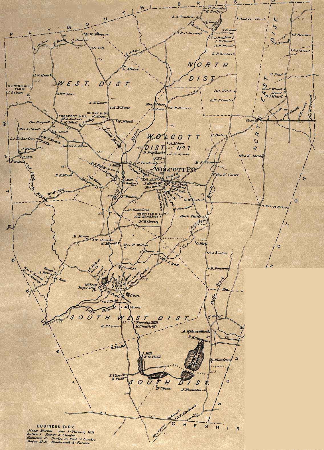
But because of the availability of a map of the town that is posted on the wolcotthistory.org website (*3), we have a unique opportunity to look at the geography of the census. And we can use this to explore a couple of questions that some others have had about the town’s history at the time. I’ll bring those up as appropriate below.
[1868 Map]

How the Census Was Taken
Unlike today’s Federal Census, where every household receives a form in the mail that can be filled out and either mailed or submitted online, the census in times past was done by a census taker visiting each home in-person, interviewing the head of household or their spouse, and filling in the appropriate line on the census form. The person who was the census taker for Wolcott in 1870 was a man named Sturgis Judd. He was 61 and lived in Waterbury with his wife and 25yo daughter who was a milliner. His primary occupation was that of “Collector of Bills”, but for two months in the summer of 1870 he worked full-time taking the census. Beginning on June 1st, he and one other man took the census for the entire city of Waterbury. Sturgis did 2/3 of the homes (about 10,000 residents in over 1300 dwellings). He finished this task in mid-July, signed the last page (he had completed 227 pages of the 333 that it took to record everyone in Waterbury), then immediately moved on to taking the Wolcott census.
Having done 1300 dwellings in 6 weeks, and with only 120 dwellings in Wolcott, he may have thought that Wolcott would only take a few days, but since all the roads in Wolcott were unpaved and the houses often far apart, it took him most of a week to finish tabulating the 491 names in the Wolcott census.
Sturgis was very thorough in his work, noting for each person
their name, age, gender, race, occupation, and all the other information
required. A few interesting statistics from my analysis:
·
490 were “W”hite, there was only one “M”ulatto
(colored) farm laborer
· Nearly all occupations were “farmer,” “keeping house,”, “at home” (young children), “at school,” or “farm laborer”. Some of the other “occupations” were domestic servant (4), clergyman (1), school teacher (3) (more on this below), tanner (2), and about 10 or so miscellaneous occupations.
Working the way around the town
Because of the availability of the map from just two years earlier, it was easy to match the family names from the census with the names associated with each home and plot the path that Sturgis took around town. Note in the below that I am using the names of current day Wolcott roads, I am not sure what the names were back then.
He began in the SW corner of the town on what is now Meriden Road, the first home being that of Sheldon Hitchcock. He then went up Todd Road as far as Central Ave, then across Central Ave to East Street, and up East Street/County Road. This covered all seven families in the South School District. Here is the first part of page one of the census as an example.
[First part of page 1 of 1870 census]

Continuing up County Road, then Woodtick Road as far as Catering Road, he visited 9 families in the Central School District. He then went in Beecher Road, going down the road that led to where the New Britain reservoir is today, then back and up the rest of Beecher Road as far as the Norton Farm. This covered all 9 families in the North East School District. Here, Sturgis ran out of time on that Thursday, 7/14. I’m not sure whether he went back to Waterbury for the night or found a family to stay with for the night. At any rate, he would have had to back track all the way down Beecher Road to Woodtick Road as Long Swamp Road did not yet exist.
Starting off on Friday, 7/15, Sturgis began back north on Woodtick Road, then continuing north on Route 69. Then he went in North Street to Spindle Hill Road, going slightly north on that road as far as the Bristol line, then back south. All 17 families here would be in the North School District. Continuing on Spindle Hill Road, Andrews Road and other side roads, and ending up on Lyman Road, he visited all 22 families in the West School District before once again running out of daylight.
On Saturday, 7/16, Sturgis began by continuing on Potuccos Ring Road to Route 69 as far as Center Street, then up to the center of town and visiting families there and on Bound Line Road, visiting a total of 23 families in the Center School District. He ended up at the home of the pastor of the Congregational Church, Warren Finch. There was no census taking on Sunday.
On Monday, 7/18 Sturgis began by going down Brooks Hill Road (the first family being the Brooks family after whom the road is named), covering the last 3 families in the Center School District and then making his way down toward Woodtick Road visiting 10 families in the South West School District.
Finally, on Tuesday, 7/19, Sturgis finished the remaining homes in the Woodtick/Todd Road area, then went down Woodtick Road back to Waterbury, visiting the last 20 homes in the South West School District.
It was a long five days, plus a day of rest on Sunday, of going to every home in Wolcott! But the record of all his visits is preserved in Sturgis’ excellent handwriting for us to see 150 years later.
Schools in Wolcott
I was asked recently if I thought that the entire network of one-room schools that had originally been established continued through the decline in population. Although the 1868 map shows six school buildings, were they all used, or were schools combined?
Before answering that question, a few words about schools in the mid-1800s are in order.
While compulsory education was not legislated in Connecticut until 1872, most people were already going to school in 1870. Local schools were often one-room schools which only served the elementary years (grades 1-8) with high schools only available in larger cities and students going on to “higher” education boarding nearby. Teachers were required to be unmarried and were nearly all female. They were generally in their late-teens or early-20s (the only requirement being that they had already finished elementary school). If they did not live nearby (often the case), then they boarded with a local family.
Such was the situation in Wolcott. All the students noted as being “at school” were between age 7 and 14/15 (remember that school began in grade 1, there was no kindergarten, and ended after grade 8). There were 91 such students among the 491 residents and there were three teachers in the census. The distribution of students among the six school districts noted on the 1868 map was as follows: N-14, NE-8, W-19, C-24, SW-20, S-6.
There were three teachers in the census. In the North East District was Anna Root, age 17, who was boarding with the family of George Atwood (who had one child of school age). As I had noted in (*2), Anna’s home was in the Woodtick area of town, but she travelled north to the Atwood home at the beginning of each week and then returned home on Friday after school – it being too far to make the daily commute to the North East school.
In the West District was Ella Crandal, age 22. She was from Hartford, and she was boarding with the Richardson family about 5 houses away from the West District school. In the Center District was Sarah Finch, age 25. She was the daughter of the town clergyman and lived right across the green from the Center School. But what about the other three schools?
I suspect the North District school was served by a teacher who lived in Bristol as it was so close to that much larger town. But with 14 students, it was certainly large enough to continue. Similarly, the South District school was served by a teacher from Waterbury as it was right on Meriden Road which was the border of Waterbury.
For the large South West District school, there are two possibilities. One is that the teacher lived in Waterbury and commuted up Woodtick Road each day. I recall seeing information about individuals who made that commute in the past. But the other possibility is related to the timing of the census.
When Sturgis Judd began taking the census, it was Thursday, July 14. When visiting the home of George Atwood, Anna Root was noted as living there – it being a school day when she would have been boarding. But by the time he visited the Root family home in the Woodtick area in the late afternoon of Monday, July 18, Anna was there instead and had the distinction of being counted twice in the same census. I suspect that Friday, July 15, was the last day of the school term, so that by the following Monday, Anna was back home as July 18 was no longer a school day. Since she was back home, then the teacher who had been boarding in the Woodtick area would have also finished for the term and she similarly would not have been counted in the census as she would have returned home (possibly to Waterbury). So, whether the South West teacher was commuting from elsewhere, or whether she was no longer boarding in the area due to the timing of the census, we have a logical explanation of why she was not counted in the 1870 census. In the latter case, Anna Root being counted twice just made up for the South West teacher being missed in the census.
The Two-Home Problem
If you study the 1868 map closely, you will note that there are three instances where there are two dots listed with the same name. Two of the instances are on Spindle Hill Road in the West School District – the two occurrences of Albert N. Lane, and the two occurrences of Levi Atkins (one in the West District and one just over the border in the North District). The other occurrence is in the North East District where George W. Atwood appears twice – once on the E-W road near the eastern edge of town, and once on the N-S road that goes down toward where the Southington Reservoir is currently located.
Most farms of this era, and Wolcott was nearly all a farming community, would have had a building complex – the main farm house where the family lived, one or more barns that held animals, hay, or other farm equipment, and possibly other smaller outbuilding for storage purposes as well. In any case there would have been only a single small dot on the map needed to identify the location of this complex of buildings and the owner of that complex.
But what about a situation where a large farm has additional fields located away from the main complex? If there were additional buildings associated with these additional fields, how would one know when driving past them who they belonged to? I believe that is the case here. Note that for both Albert Lane and Levi Atkins, that the second dot on the map is not only down the road a bit, but that it is on the opposite side of the road. In order for anyone using the map to know who to contact regarding that isolated building, they can see the presence of another building farther up the road with the same owner.
The situation with George Atwood is a little more complicated. We can be pretty certain that George and his family lived in the home at the eastern boundary of the town. That’s because when Sturgis Judd was visiting each home taking the census, he went to the homes of Stillman Bronson and Anson Smith before going to the homes farther down the road – George Atwood and Jarvis Bronson. Then he went to the George Wiand home up on Beecher Road near the North East School next. This visit order is pretty good confirmation of which dot on the map represents the home where the Atwood family lived (and which is close enough to the school that it would have been a logical place for Anna Root to board during the week).
[George Atwood map]

The N-S road heading down toward the current Southington Reservoir was already abandoned by 1868. Although there had been several homes there in the late 1700s, the farms had all been abandoned and no one lived there anymore. It remains an abandoned road to this day, although it is still open to hiking and the CT Blue Trails uses a portion of the northern part of it. But in 1868 there was still one active building on the west side of the road – apparently a barn that was owned by George Atwood who was trying to farm one of the still existent fields that he had purchased along with the ones around his house. It’s possible that this barn is what my cousin Rob saw on a recent hike as all that remains is a 20’ wide foundation right alongside the road.
Conclusion
The availability of this old map that is only two years removed from the 1870 census of Wolcott has made this analysis all possible. I’m grateful for the Wolcott Historical Society for preserving these artifacts from the town’s past, as well as for the current technology that makes things like scanned images of century-old census records available via the Internet. Doing historical research from the comfort of one’s home is so much easier than having to visit a library that might have such things on microfilm.
Notes:
*1 - https://ramblinrussells.blogspot.com/2015/04/wolcott-history-chronology-of-wolcott.html
*2 - https://ramblinrussells.blogspot.com/2017/12/genealogy-story-tangled-wolcott-web.html
*3 - https://web.tapr.org/~wa1lou/whs/1868mapA.jpg
No comments:
Post a Comment